


Cascade

Specialized77
User GUIDE
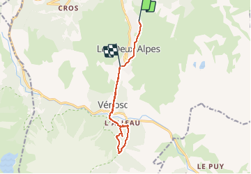

Length
11.3 km

Max alt
1713 m

Uphill gradient
1044 m
Km-Effort
25 km

Min alt
933 m

Downhill gradient
1115 m
Boucle
No
Creation date :
2020-08-24 11:46:34.094
Updated on :
2020-08-24 15:25:58.807
3h15
Difficulty : Very easy

FREE GPS app for hiking
 SityTrail
IGN / Geographical institutes
SityTrail Plus
The world is yours!
About
Trail Walking of 11.3 km to be discovered at Auvergne-Rhône-Alpes, Isère, Les Deux Alpes. This trail is proposed by Specialized77.
Positioning
Country:
France
Region :
Auvergne-Rhône-Alpes
Department/Province :
Isère
Municipality :
Les Deux Alpes
Location:
Unknown
Start:(Dec)
Start:(UTM)
273804 ; 4989146 (32T) N.
Comments